Friday, September 17, 2010
28 Eddies, Steamboats and Calico Rocks
28 A History Lesson Opens Questions.
No, I am not about to launch into a diatribe against the War of Northern Aggression, although I have been known to do that. The couple that gave me the pizza the night before were history buffs of a sort. They told me about a wall I would see further down the river. The wall, called an eddy, was built by slave labor according to my dinner pals and was done at the direction of the steamboat companies. Apparently, then as now, the river shoals and channels needed navigational help in the drier times.
The steamboat companies were paid by the amount of freight, whiskey and cotton they could bring back down the river. But first they had to get up the river to the towns and riverside docks. When they came up from Memphis, the boats were full of finished goods for the settlers in the mountains.
If a particular place was too shallow, they could partially dam the river from either one or both sides leaving a gap in the middle, thereby swelling the channel big enough for steamboats to pass. When the wall or walls forced the water into the narrow passage, the net effect was to have deeper, swifter water through the channel.
The walls were made of large stone or in some cases boulders. Snag boats and other workboats would bring the slaves up and build the walls to improve navigation. I am told without the eddys there would have been no way to deliver goods that far into the mountains. There were rugged roads leading out of the hills but nothing that would allow passage of large cotton wagons on those long distances to market. The terrain was just too rugged and the horse power needed to get through the ravines and gullies would have had to have been more like a 409 Chevy than a four mule or oxen team. Since there were no railroads, that meant there could not have been major commerce for the communities upstream. To make transportation matters worse, weather was a major factor when dealing with dirt and rock roads. When a river or stream was to be crossed, ferries or low water crossings were the only options. Steamboats opened up the markets of the entire world to the hill countries’ products what few there may have been. The little paddle wheelers were instrumental in the development of the Ozark nation.
When I heard the story about the slaves, I doubted it. I thought the steamboat companies probably had employees who did that sort of work full time. In some cases I would guess they even contracted that sort of work out to specialized workboat crews. It could have happened. I know there were slaves working the docks in Memphis. I mean, where else would we have gotten “tote that bar and lift that bale.” Maybe that was the source of labor needed for the construction projects on the river. I don’t know where to turn for this type of historical information. A book on the riverboats role in the development of the southern mountains would be a hell of a read.
The other factor here is the locals had a strong incentive to see the steamboats coming up the river. Again, other than wagon transportation, without the steamboats there could be no merchants because there would be no goods to stock store shelves. I don’t think the slaves would have been local as there would have been little need for slaves in the hill country economy. There wasn’t enough cotton grown in the hills due to the soil and other agricultural conditions. Cotton was the cash crop that brought in slaves. Besides that, slaves were very expensive and there was little cash money to be had in the hills. So, yes and no. If slaves did build the walls, according to present day legend, they would have come up the river with the workboats before the steamboats could traverse the shoals. I for one would love to know when and how the “eddys” were built.
I heard from some of the local folks that steamboats at one time made it up the White as far as Flippin. To me, that is completely amazing. I see the dams and the eddy and ride along in a little tiny, shallow, draft canoe and drag bottom several times a day. Yet, here these old timers from well over a hundred years ago brought those big old paddle wheelers up the river even further up than I was traveling in a canoe. Wow.
Having been out of the hills for almost fifty years does not help my knowledge of the local history. The eddys grabbed at my curiosity. I hope to I learn much more in the future.
My previous trip through Steamboat Shoals had been at high water. I read the river to stay right until I could see a channel open up. That’s exactly what I did. While fighting fog and rain, I noticed the water looked weird like it was damned up and going over a falls of sorts. That was on my left as I passed by. I couldn’t see on the other side nor did I have time to look too hard. But it just did not look right. On this trip through the shoals the water was really low. I was curious about that weird looking water I had seen on the previous outing. It was a huge rock eddy. The water was backed up and was going over and around the boulders. Those same rocks were now higher than my head. Glad I didn’t read the water wrong on that one. It would have been like going over a waterfall.
That wall was the one I took to be the slave eddy the folks told me about the night before. I don’t know if I have them mixed up but I think that was Steamboat Shoals. The name would make sense since the shoals were partially blocked to create a channel for the steamboats. Later, I saw another smaller yet longer wall on river right. I think that was Berry’s eddy. I have to assume it was supposed to have been what the fellow called a slave wall as well.
I wonder what sources there might be about the steamboats on the White? If anyone reading this journal knows of information concerning steamboats or packet boats on the White, please email me and let us share it with others who are interested in the history of the White.
At this point the water was so low I was getting hung up on rocks and gravel where there were no shoals listed on my little map. I kind of gave up on defining shoals along the stretch of river just past Steamboat Shoals. For a good part of the day I seemed to be going over a very shallow river with never-ending shoals.
Somewhere near Red’s Landing I spotted two real “sure nuff Bald Eagles.” They were flying around and apparently found themselves a meal of fish on a gravel bar. They dropped down and stayed to eat while I passed by fairly close. It was neat to see real eagles making a living on the White. I never thought I would see the day.
Down below Mathis Island I saw about a dozen fly fishermen wading in the shallows. The lady closest to me said she was doing well. I figured this must be a darned good place or all those people wouldn’t be out there flailing away with those fly rods. I should come back there someday and fish with them. There is one thing the wade fisherman has to remember at all times. Always have an escape route near. If that water comes up you are going to need a way to shore. The other thing you might want to do is keep one eye up river. Be very aware of your surroundings at all times. When you notice a little increase on depth or speed of the current, pay attention. It might save your life.
Do not park your car near the river. It will become one with the river if left there long enough. Make sure your car is out of reach of the high-water mark. This river does not need a rainstorm to sweep you and your property away. All it needs is enough gates to be open and for you to do something foolish, like stay in it too long. Hear me now. This is important.
The last few miles before reaching Calico Rock were a lesson in history and geology. All you had to do was sit and drift. Cast a few times trying to fish, but mostly just look at the beauty of the Ozarks. The Calico Bluffs are so unique and for the most part unchanged, no thanks to the railroad powder monkeys. The water spreads out and the river becomes much broader. The bottom for the most part is now gravel and shallow. Once again looking over the side, you cannot believe how wonderfully clear and clean this river truly is. Throughout what few older documents I have found, everyone comments on the clarity of the water.
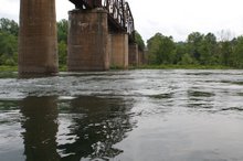
The channel becomes elusive and I drag bottom and have to get out and push from time to time. Finally I found a narrow deeper channel on river left very near the shoreline. I used it most of the rest of the way to Calico Rock. Once I came into view of the bridge, the water deepened and I motored right into the Jenkin’s Trout Dock.
I had to chuckle as I got closer to Calico Rock. This was the same stretch of river that Chris Leavitt and I had started out. The water was as smooth as glass. It was the very best boating water I had seen since Bull Shoals Dam. The two big cheechakos couldn’t handle this easy water. I am so glad we scared ourselves. If we had gone up to Bull Shoals and put in with seven gates of water, I hate to think of the consequences. I think the way I did the float alone, thereby getting the experience, was a good thing. A little less water the first day out wouldn’t have hurt anything but I made it, so there.
Subscribe to:
Post Comments (Atom)


No comments:
Post a Comment