Buffalo City and the GPS fiasco.
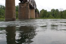
Let me get this out of the way. I haven’t seen any buffalo in Buffalo City. I haven’t seen any city in Buffalo City. I have seen a Game and Fish Commission ramp and access area. I have seen what appears to be a campground along the river. But I am not sure what I saw. I did see people walking along a well maintained shoreline so I assumed it was a resort of some sort. I know the mouth of the Buffalo River is not more than one half mile downstream from the access area. I am pretty sure the bluff across from the ramp is Stair Bluff and I think it may be the side of Turkey Mountain but I’m not sure about that part.
There may be a town up on the road leading to the river but I haven’t seen it. The next time I’m in that area I will go see if I can find out more and if there is a café, I am going to try to order a Buffalo Burger.
A couple of miles before I reached Buffalo City, the batteries failed on the GPS. I had not hit the three-hour mark this time. This was 12 miles at about a six-mile per hour average. It was, however, long enough for my posterior to be barking at me. The narrow little cane bottom canoe seat had already started to impose its’ impression on not only my buttocks but my back as well. I was going to have to figure some way to beat this problem.
Back to the GPS. It was a DeLorme PN-20. I had been told by an REI staffer, it was the best off-road topo gear available and so new they didn’t even have it in the stores. I ordered it from the factory and paid full retail for the rig. I got the chargers and all that they called “road gear” or something like that. We also bought the deluxe package to get the mapping software for the computer. That was the important part. We were told by DeLorme, almost any GPS could make a trail but making the maps was the specialty of the house DeLorme.
After three frustrating weekends, I think my computer guru wife would beg to differ with that assessment. Tedious would be kind from her standpoint. Amy was having a terrible time learning the “geek to geek speak” software in building the maps. She had printed out a three ring binder some two inches thick of instructions and still could not figure the thing out. There was nothing intuitive about the program and to make things worse when you got something finished if you tried to do something else it would wipe out the previously finished product.
Amy took DOS twenty years ago and has been using computers of all sorts ever since that time. She never has to call a help desk and does everything but write her own programs. Amy is seriously computer savvy. I, on the other hand, am not. She should have breezed through a consumer product like this. To her it was based on non-sensical logic and continually threw up roadblocks to routine procedures.
On my end, I was having a hell of a time learning and operating the GPS unit in the field. I would lay the manual down beside me and try to walk through the instructions to achieve simple goals like lay down a track. I wasn’t trying to get from Chicago to San Francisco and figure ETA’s or anything. I just wanted to lay down a track so I could make it follow me as I went about my travels. The next step would be to download the info with the markers I blazed, so we could build a map on the supposedly great topo’s from DeLorme.
One of the main problems was the nomenclature they used. I referred to it as geek speaking to geek without regard for the consumer or end user. Reading the wording in the GPS or in the instruction manual, was like reading another language. When I called the guy at the factory who had told me how wonderful the equipment was, I asked him to walk me through setting the GPS up for a simple tracking run. At that point, Amy had spent an entire weekend uploading their maps to the GPS unit. I thought she was going to shoot me before it was finished. Again, tedious would have been kind.
I was at REI in Plano asking for help from their resident GPS guru when the factory guy called back to assist me with setting up the tracking. He was the product manager or something. I had already had to have the charger and original rechargeable batteries replaced after the first trip. At this point I was in preparation for the Cotter to Guion trip and was trying to make sure I had the GPS thing down so the work would count this time.
I was due to leave for Cotter the next day and needed help. That morning I had called the DeLorme help desk or technical assistance desk, whatever they call it. I had gotten into an argument with the staffer who was handling my call. He was telling me there was nothing wrong and I was asking if that was the case why didn’t the map show up. I got ticked and asked for the manager. He came on all ticked off and eventually told me my learning process was not their responsibility. If the machine was not broken don’t call them. That is when I called the guy who had basically sold me the machine. It took him several hours, meetings you know, to call me back. I was, by this time, desperately seeking help from the REI guys in the Plano store.
The fellow was nice enough. I think he got ticked when he heard how I was treated by his “help” desk. He tried to walk me through his procedure to get my problem straightened out. It didn’t work. As I told him, he was speaking from a satellite and I was still on the runway. The words he was using to instruct me were his company’s words. They were geek speak and I might as well have been listening to someone speaking Greek because I had not a clue as to what he was saying. I still don’t know why they could not have used words that meant something to the everyday consumer especially since it was a consumer’s device. Those people are going to fail at this venture. I eventually had to send all the DeLorme equipment back for a refund. It was just too hard to use and, as I learned from the REI guys, they had a really bad reputation when it came to the help desk.
I instinctively knew it was too hard for me to deal with alone. Then when I ran into all that attitude at the help desk, I was sunk. Therefore they are going to sink as well. A couple of weeks later I went to a field GPS demo session put on by REI. There were several people there, none of which I would call a computer whiz. All had Garmin equipment and the instructor walked us through setting the units up from scratch. I was amazed at how user friendly they were. There were symbols that actually made sense to the consumer. The buttons were easy to understand and didn’t take a thick manual to figure out. Within a very short time I was feeling comfortable with the Garmin and realized I had bought a line of hooey.
Later I did go to the REI store and bought the Garmin top of the line GPS and the National Geographic Topo software for my area. There is usually a reason if one company is out selling the rest of the industry a gillion to one. Maybe I should have thought about that instead of listening to the hooey tipster.
The other knock I have on the supposed rock star of GPS units is that side by side in difficult locations the Garmins are able to get signals when the DeLorme hasn’t a clue. That could make a difference in the high-walled canyons of the float-fishing world. The best thing I can say about DeLorme is my contact took pity on me and accepted the products back.
Now back to the river. The DeLorme batteries went out in less the three hours. I want to make sure I say these were the new replacement batteries sent to replace the old ones that went out on the last trip. I had charged the darned things all night along with the older pair. But this time I knew exactly where my old funky Sam’s Club cheapy AA batteries were located. I had actually anticipated the factory’s failure. Of course the weather and the river were cooperating as well.
I had made an equipment change. Instead of the paddler’s wet bag for my camera equipment and batteries, I was using a photographer’s Pelican hard case. The thing was bulky, but it protected the gear from bumps much better and it was actually probably better in the waterproof department. I was keeping the case at my feet. The Pelican contained two professional grade cameras with lenses ready to shoot. This trip I was determined to get some descriptive pictures. This was much better access and protection for the gear.
I opened the back of the GPS and removed the old batteries and replaced them with my cheap AA’s and turned the thing back on. Whammo, we had GPS again and had not missed more than 100 yards of river. If you read the previous story, you will realize I am floating this section for the second time because my batteries failed in a storm and I lost two whole sections of my trip. That was a dangerous way to learn the value of the GPS unit and its batteries.
When we started the blog, the original idea was to pass onto others information about not only the river but the equipment as well. The GPS story will evolve and I will be adding information as we try new products.
Subscribe to:
Post Comments (Atom)


No comments:
Post a Comment