Monday, July 16, 2007
Chapter 4 The dreaded moment...Proud Mary meet the shoals.
As the boat picked up speed I was torn between looking at the campgrounds and trying to figure out how far it was to the first shoals. That dilemma didn’t take long to sort itself out. As soon as I looked at my Game and Fish map, I saw I was going over a shoals right then. The GPS can’t tell you about danger but it was doing a good job of telling me where I was and how fast I was going. At that moment I was thinking how I would really like to slow the whole deal down to slow motion. I just wanted to see what was ahead of me and the fog was coming in thicker. The visibility range was growing smaller and smaller. Not a good thing at all. No Sireee.
I knew Gaston’s couldn’t be far down river but my little map didn’t show the distance. My GPS knowledge was a little, no, a lot sketchy at this point so I just motored slowly and watched the shore. Islands were an immediate scare for me. I never knew which side to take. It seems that I always have to sweat it out until I can get close enough to see which is the wider channel. That makes me nervous because I don’t know what the shoals or current situation will be at that point nor do I know if my little motor will pull me to the correct side of the island if I don’t read the water quickly enough. Hell I’m new, the equipment is new, and I have never done any of this in my life. Its’ ok to be nervous, doofus. Don’t sweat it.
As I searched for a little cheater help on this deal I noticed the GPS had the county line running down the center of the river. I assumed the channel would be considered the dividing line between the two counties. That lead me to follow the route of the county line. Hopefully the river channel had not changed since the counties divvied up the land. The river changing course and creating oxbows apparently would happen more often in the delta counties than in the rockier hill country. This would be especially true in the leatherwoods where the hills tend to come right to the edge of the river. Limestone cliffs tend to dictate where the river is going to run for millions of years rather than a decade or so as in the delta.
Back to the river and our trout trail…..
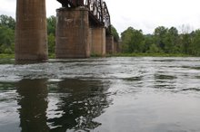
Just below the State Park and before you get to Gaston’s, the little boat came to its’ first island. At Caine Island you have to choose the left side of the split and, in the process, got the first real shoals. This is one of those darned if you do and darned if you don’t deals. Go to the right and the channel is too small. Go to the left and you are with the main channel but it goes over some significant shoals. Since I was there at high water I can’t supply any information as to how these or any other shoals are to be run nor would I. Neither can I tell you what the other side looks like during normal water levels. There might not even be an island or a second channel on the other side but I wouldn’t know having been down this route only one time and at high water.
Every day the water will be different and each voyageur will have to read the water and make the best decision they can for that given moment. Each shoal on the river will change with the amount of water the dam is discharging.
You are always at the mercy of the power generation needs. Sometimes like this trip, they are putting out way too much water for fly fishermen’s wading comfort. It was uncomfortable for the float fishing as well as canoe newbies trying to GPS and fish at the same time. Kayakers, sans fishing, would probably have a ball.
But during some extended low outflow periods, they don’t let out enough water to keep the trout alive. There was a law passed, but I don’t think implemented, which will require the power company to allow a minimum water flow to feed the river. At least enough to keep the trout alive. So far the power company just does whatever they want, trout be damned.
The other thing everyone should know about this particular dam and it may be true of all power generation operations is they will never tell you their future water flow intentions. They will tell the Game and Fish Department how many gates they have had open. Southwest Power will tell game and Fish what they are doing right now. But they refuse to tell anyone of their future plans no matter what the rest of the world is trying to plan. Tough situation for Game and Fish folks to be in I would say. I understand how it must really frustrate people who are trying to make any sort of plans concerning the river. This affects the river for more than a hundred miles of shoreline. I really have no idea at this point how far down it does affect the water level. It is the primary source of the White until you pass enough feeder creeks to equal and surpass the volume coming out of the dam.
Back to the River….
Caine Island seemed to have shoals the entire length of the island. At least the water was bumpy and somewhat turbulent all the way through the narrows. After I passed the downstream tip, all seemed to smooth out. Soon after Caine Island, Gaston’s appeared on the left. Barely a month had passed since Chris Leavitt and I had eaten some really great smoked trout in that dining room. The place reeks of old money and charm. The food was good and not too pricey. About like Dallas prices for the same menu I would guess. Leavitt might have a different opinion since he was the guy picking up the tab that day.
Soon after Gastons, things began to pick up. The seventeen-year-old Mad River Explorer went thru Partee Shoals, Bruce Creek Shoals, Three Chutes and past Turkey Bottom Island, Blue Hole and White Hole. Seven miles from the Dam, I encountered White Hole Access. The ramps are provided by the Arkansas Game and Fish Commission. They usually have a couple of portable outhouses and a trash dumpster along with the boat ramp. They are a very welcome sight and a safe place to pull off the river. In many areas there were flooded woods on one side and high limestone bluffs on the other. So these ramps really come in handy even if all you want to do is stretch your legs or grab a bite to eat from your kit. But the main reason I liked them were the port-a-johns. Ah yes, very important sometimes.
At this point I had been on the river less than 7 miles and had crossed the same number of shoals. I needed a chance to catch up with my heart. They were not dangerous but they just made you very well aware that the river was in control and you were just visiting. The other part was maybe even more important. The morning’s coffee was taking it’s toll and I needed a pit stop badly. This is where the fog and the current become nefarious. They teamed up on me. I could not see either bank. I mean this fog was thick. I could see upward to the heavens, it was just a really heavy river fog. I couldn’t see 40 yards in any direction. At some points the fog danced and twirled in the wind. I wondered if this was one of those other world dimensions I had read about. Carlos Castenadas or Cormac McCarthy maybe? Who knows, just another faint memory in an overflowing hard drive?
All of a sudden, I heard a scary distant sound. This was one that should have been an obvious concern but I had not even thought about. The scary sound was a fishing boat coming up river but not be able to see it. It seemed like an eternity before the boat, usually a 20-foot Jon boat with a guide and his two or three passengers, would appear. When they, did the boat would usually be off my bow by some 40 yards and a little to the right or left. I was probably running in the wrong track. I had chosen to go as straight down the middle as I could since the only landmarks I could see were tops of trees or cliffs on either riverbank. If there weren’t any tall objects bordering the river then I had nothing to judge the shoreline. That was it. Look right, look left then adjust your course by trying to stay half way between what you guessed was the shore. I think I passed and island or two without knowing if I was on the correct side. I couldn’t always stop and look at the GPS to use my county line theory.
The guides were gracious when most slowed their boats down to a crawl while passing. I wasn’t putting out much of a wake as the little canoe was still putting along at trolling or minimum throttle. Sometimes, but not often, I would be passed by a private boat. At least they didn’t look like a guide and his clients. The private boats reminded me of Dallas drivers and did not slow down. That little bit of river etiquette could be big trouble for a canoe or overloaded small Jon boat. Big waves are not our friends and the guides recognize the fact. I think they probably do that for each other as well. Call it hillbilly manners but it is mostly common sense and the Golden Rule. I appreciated it for darn sure. Thanks for the courtesy y’all.
Here’s my advice to you who follow these “Trout Trails”, especially you old boomer guys. Don’t pass up any ramps or their services. You will suffer the consequences I promise. Apparently the Arkansas Game and Fish Commission ramp planners are old timers like me. Otherwise they would never of thought to place a ramp at the halfway point between every major take out on the upper river. I know they will deny what I just said and say it is for better access for the fishing public but I will always know I have discovered the truth.
These guys scouted the potential ramp location by boat. They had the same bladder urges any other red blooded boomer aged, coffee drinker would have at mid morning. Ergo the ramp locations make ideal pit stops.
Thank you Game & Fish and Red Wilson.
Subscribe to:
Post Comments (Atom)


No comments:
Post a Comment